Latest topics
» K 1200 GT FOR SALE ASKING R112 000.00 onoby STEVE 19th November 2010, 13:45
» Three week Bliss
by Corlia 19th July 2010, 09:39
» From the UK - new element found in SA
by DaveS 7th July 2010, 18:53
» Tourmaster Airflow Pants
by Heretic 7th July 2010, 08:02
» Forum lockdown
by Admin 6th July 2010, 22:17
» New website, new forum!
by Marnus 6th July 2010, 20:10
» Who Will Win The Soccer World Cup
by 1150 adventure 4th July 2010, 12:06
» New forum?
by LeRoy Olivier 2nd July 2010, 10:40
» Your favourite photos
by Gert_GS_650 1st July 2010, 06:32
» NEW Clubhouse
by Thomas 30th June 2010, 21:44
Who is online?
In total there are 84 users online :: 0 Registered, 0 Hidden and 84 Guests None
Most users ever online was 181 on 10th February 2021, 11:40
Statistics
We have 359 registered usersThe newest registered user is Kruger
Our users have posted a total of 17455 messages in 1456 subjects
How to make a track in Google Earth and open it in Mapsource
2 posters
Page 1 of 1
 How to make a track in Google Earth and open it in Mapsource
For everyone that would like to get paths, tracks, and roads that they see on Google Earth opened in Mapsource, so that they can transfer it to their GPS unit, this is how:
I will first list the steps, then illustrate with pics, easy peasy.
First, what you need:
1. Google Earth
2. Mapsourse
3. GPS Trackmaker (download it FREE from www.gpstm.com)
Steps:
1. Draw the path in Google Earth
2. Save the path as a “.kml” file from Google Earth
3. Open the “.kml” file in GPS Trackmaker
4. Save it as a “.gpx” file from GPS Trackmaker
5. Open the “.gpx” file in Mapsource
6. You can then save it as a “.gdb” file.
See easy as pie.
For example:
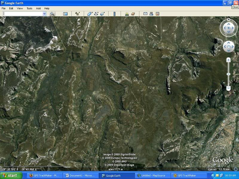
The short-cut from Golden Gate to Monontsha Border Post (Heuweltop) is visible in Google Earth but not on my Garmin 2008 Streetmaps.
Heuweltop track visible in Google Earth
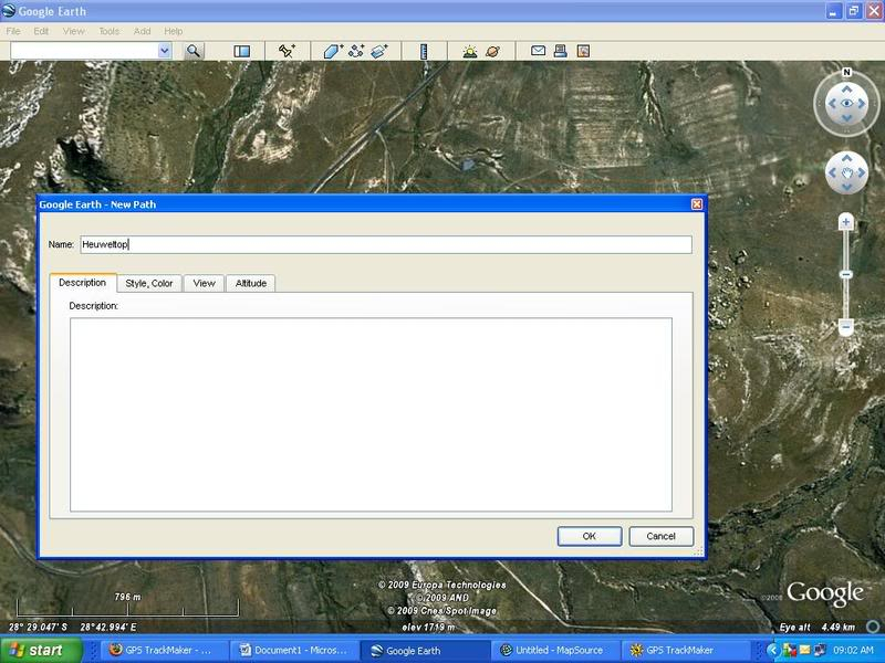
To draw a path in Google Earth, click on Add => Path and then name your path. Remember NOT to close this box.
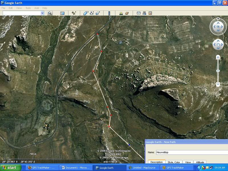
Now, start to draw the path by clicking on the screen in Google Earth where the path goes.
Once you have completed your path in Google Earth, click “OK”in the box you left open while drawing the path. Then click on the path in the Sidebar and “Save Place as”.
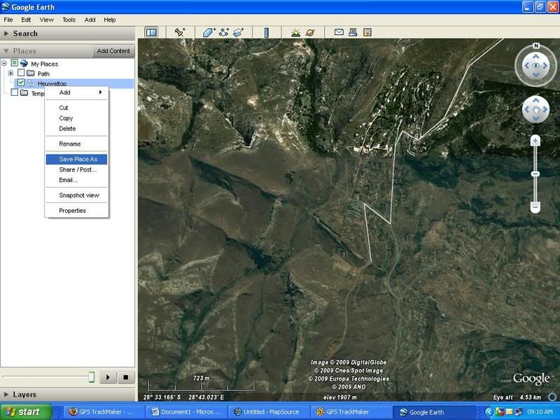
Save it as a “.kml” file
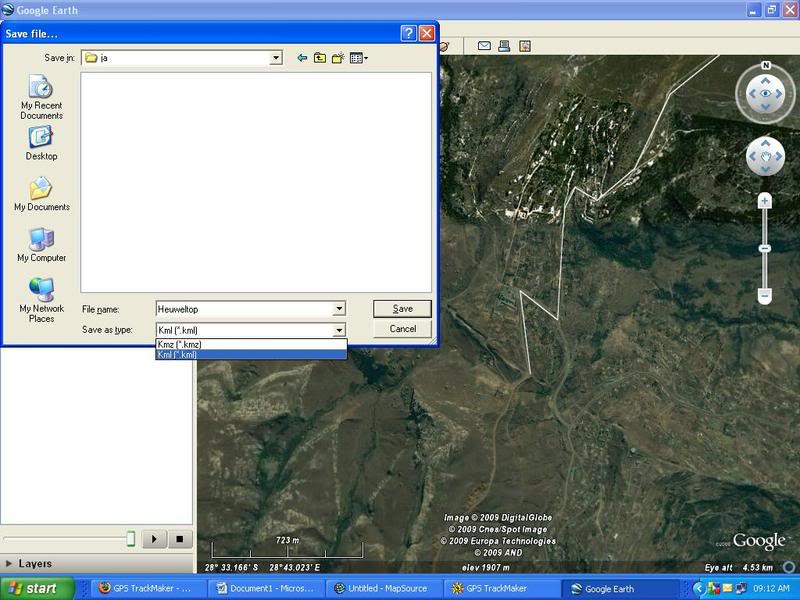
You can now close Google Earth and open GPS Trackmaker. Open the “.kml” file jou just saved in GPS Trackamker.
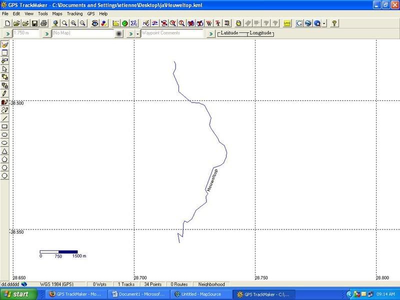
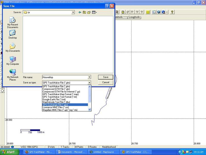
Now, save it as a “.gpx” file
Now you can close GPS Trackmaker and open Mapsource. Open the saved “.gpx” file in Mapsource.
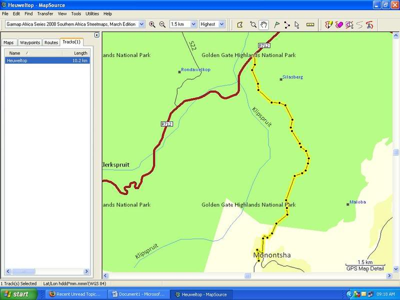
And now just save it as a normal “.gdb” file and Bob’s your Uncle!!!
Hope this helps!!!!


I will first list the steps, then illustrate with pics, easy peasy.
First, what you need:
1. Google Earth
2. Mapsourse
3. GPS Trackmaker (download it FREE from www.gpstm.com)
Steps:
1. Draw the path in Google Earth
2. Save the path as a “.kml” file from Google Earth
3. Open the “.kml” file in GPS Trackmaker
4. Save it as a “.gpx” file from GPS Trackmaker
5. Open the “.gpx” file in Mapsource
6. You can then save it as a “.gdb” file.
See easy as pie.
For example:
The short-cut from Golden Gate to Monontsha Border Post (Heuweltop) is visible in Google Earth but not on my Garmin 2008 Streetmaps.
Heuweltop track visible in Google Earth

To draw a path in Google Earth, click on Add => Path and then name your path. Remember NOT to close this box.

Now, start to draw the path by clicking on the screen in Google Earth where the path goes.

Once you have completed your path in Google Earth, click “OK”in the box you left open while drawing the path. Then click on the path in the Sidebar and “Save Place as”.

Save it as a “.kml” file

You can now close Google Earth and open GPS Trackmaker. Open the “.kml” file jou just saved in GPS Trackamker.

Now, save it as a “.gpx” file

Now you can close GPS Trackmaker and open Mapsource. Open the saved “.gpx” file in Mapsource.

And now just save it as a normal “.gdb” file and Bob’s your Uncle!!!
Hope this helps!!!!

KnopKop- Committee member

- Number of posts : 823
Age : 45
Location : Pretoria
My bike : 2008 BMW X-Challenge
Registration date : 2008-06-04
 Re: How to make a track in Google Earth and open it in Mapsource
Will obviously need some practice with that... 

DaveS- Committee member

- Number of posts : 1428
Location : Centurion
My bike : R1200GSA: R1200S(I think - has been annexed by Dorothy): S1000RR
Registration date : 2008-07-28
 Similar topics
» MapSource
» Heaven on earth.......and how is.........
» Can the Proteas make it?
» Darling, does this make my bum look fat...?
» Track day with a difference
» Heaven on earth.......and how is.........
» Can the Proteas make it?
» Darling, does this make my bum look fat...?
» Track day with a difference
Page 1 of 1
Permissions in this forum:
You cannot reply to topics in this forum